觀云識天:這6種氣象云幫你預知天氣(組圖) Here are 6 clouds you can actually use to tell the weather
中國日報網 2018-07-05 08:57

雖然現在電腦預報天氣的技術越來越先進,但是天有不測風云,天氣預報總有不準的時候。其實,早在古代,人們就已經會“看云識天氣”,學會看云的形狀,你就能預知幾小時后天氣的變化。今天我們就來認識幾種常見的氣象云。
1. Cumulus['kjumj?l?s] 積云
Clouds form when air cools to the dew point, the temperature at which the air can no longer hold all its water vapour. At this temperature, water vapour condenses to form droplets of liquid water, which we observe as a cloud.
空氣冷卻到露點的時候就會形成云,在這個溫度,空氣已經無法承載所有的水汽。在露點溫度下,水汽凝結成小滴的液態水,也就是我們所看到的云。
For this process to happen, we require air to be forced to rise in the atmosphere, or for moist air to come into contact with a cold surface.
要形成云,需要空氣被迫在大氣中上升,或者濕潤的空氣和冰冷的表面接觸。
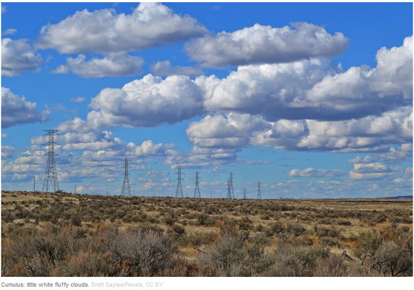
On a sunny day, the sun's radiation heats the land, which in turn heats the air just above it. This warmed air rises by convection and forms Cumulus. These "fair weather" clouds look like cotton wool.
在晴天時,陽光讓大地升溫,從而讓大地上方的空氣也升溫。這些溫暖的空氣通過對流上升,形成積云。這些“好天氣”的云看上去就像棉絮一般。
If you look at a sky filled with cumulus, you may notice they have flat bases, which all lie at the same level. At this height, air from ground level has cooled to the dew point. Cumulus clouds do not generally rain – you're in for fine weather.
如果你看見天空布滿了積云,你可能會注意到它們的底部都是平的,而且都位于同一水平線上。在這個高度,來自地面的空氣已經冷卻到露點。積云一般不會化成雨,它預示著好天氣。
2. Cumulonimbus[,kjum?lo'n?mb?s] 積雨云
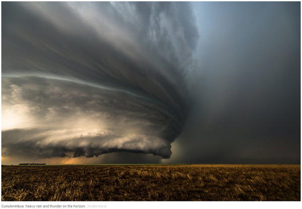
While small Cumulus do not rain, if you notice Cumulus getting larger and extending higher into the atmosphere, it's a sign that intense rain is on the way. This is common in the summer, with morning Cumulus developing into deep Cumulonimbus (thunderstorm) clouds in the afternoon.
雖然小的積云不下雨,但如果你注意到積云變大并向大氣高處延伸,這預示著強降雨即將到來。這在夏季很常見,早晨的積云到了下午可能就變成了厚厚的積雨云(雷雨)。
Near the ground, Cumulonimbus are well defined, but higher up they start to look wispy at the edges. This transition indicates that the cloud is no longer made of water droplets, but ice crystals. When gusts of wind blow water droplets outside the cloud, they rapidly evaporate in the drier environment, giving water clouds a very sharp edge.
靠近地表時,積雨云的邊界都比較分明,但到了大氣高處,它們的邊緣開始出現條縷狀。這種轉變預示著云朵不再由水滴組成,而是由冰晶構成。當一陣陣的風吹動云朵外層的水滴,水滴在干旱環境下就會迅速蒸發,讓云朵邊緣看上去很尖銳。
On the other hand, ice crystals carried outside the cloud do not quickly evaporate, giving a wispy appearance.
與此同時,云朵外層的冰晶卻沒有蒸發得那么快,于是就出現了條縷狀的云朵外觀。
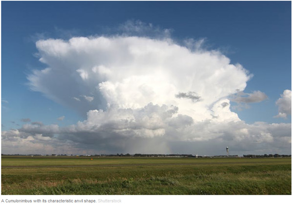
Cumulonimbus are often flat-topped. Within the Cumulonimbus, warm air rises by convection. In doing so, it gradually cools until it is the same temperature as the surrounding atmosphere.
積雨云通常在頂部是平的。在積雨云內部,暖空氣通過對流上升,在上升過程中逐漸冷卻,直到和周圍大氣溫度一致。
At this level, the air is no longer buoyant so cannot rise further. Instead it spreads out, forming a characteristic anvil shape.
上升到這個高度后,空氣不再活躍,也不再上升,而是擴散開來,形成特有的砧形。
3. Cirrus['s?r?s] 卷云

Cirrus form very high in the atmosphere. They are wispy, being composed entirely of ice crystals falling through the atmosphere. If Cirrus are carried horizontally by winds moving at different speeds, they take a characteristic hooked shape.
卷云在大氣高處形成。它們呈條縷狀,完全由大氣中落下的冰晶組成。如果卷云被運動速度不同的風水平吹動,它們會呈現特有的鉤形。
Only at very high altitudes or latitudes do Cirrus produce rain at ground level.
只有在非常高的高度或緯度,卷云才會化成雨降到地面。
But if you notice that Cirrus begins to cover more of the sky, and gets lower and thicker, this is a good indication that a warm front is approaching. In a warm front, a warm and a cold air mass meet. The lighter warm air is forced to rise over the cold air mass, leading to cloud formation.
但如果你注意到卷云開始覆蓋天空的大部分,位置變低,云塊變厚,這預示著暖鋒正在靠近。暖鋒就是暖空氣團和冷空氣團相遇。重量更輕的暖空氣團被迫升到冷空氣團上方,導致卷云的形成。
The lowering clouds indicate that the front is drawing near, giving a period of rain in the next 12 hours.
云層變低預示著暖鋒臨近,在未來12個小時將會下雨。
4. Stratus['stret?s] 層云
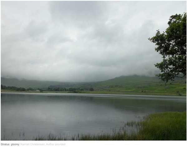
Stratus is a low continuous cloud sheet covering the sky. Stratus forms by gently rising air, or by a mild wind bringing moist air over a cold land or sea surface. Stratus cloud is thin, so while conditions may feel gloomy, rain is unlikely, and at most will be a light drizzle.
層云是低低地覆蓋天空的連續云層。層云由緩慢上升的空氣形成,或是輕風將濕潤空氣吹過冰冷的地面或海平面形成。層云比較薄,所以盡管天氣陰陰的,但卻不太可能下雨,最多是毛毛雨。
Stratus is identical to fog, so if you've ever been walking in the mountains on a foggy day, you've been walking in the clouds.
層云和霧差不多,所以如果你曾在霧天上山,那就是云中漫步。
5. Lenticular[l?n't?kj?l?] 莢狀云
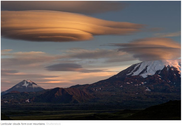
Our final two cloud types will not help you predict the coming weather, but they do give a glimpse of the extraordinarily complicated motions of the atmosphere.
我們最后要說的兩種云不能幫你預告天氣,但是可以瞥見大氣異常復雜的變化。
Smooth, lens-shaped Lenticular clouds form as air is blown up and over a mountain range.
平滑的透鏡形狀的莢狀云是空氣膨脹時在山脈上方形成。
Once past the mountain, the air sinks back to its previous level. As it sinks, it warms and the cloud evaporates. But it can overshoot, in which case the air mass bobs back up allowing another Lenticular cloud to form.
一旦經過山脈,空氣就縮回到原先的水平。空氣收縮時會升溫,云朵會蒸發。但如果收縮過了頭,空氣團就會回彈,形成另一朵莢狀云。
This can lead to a string of clouds, extending some way beyond the mountain range. The interaction of wind with mountains and other surface features is one of the many details that have to be represented in computer simulators to get accurate predictions of the weather.
由此產生的一連串莢狀云會延伸到山脈的另一邊。風和山及其他地貌的相互作用是電腦模擬器需要考慮的眾多細節之一,否則無法準確預測天氣。
6. Kelvin-Helmholtz['k?lv?n]['helmh?ults] 開爾文-亥姆霍茲浪狀云
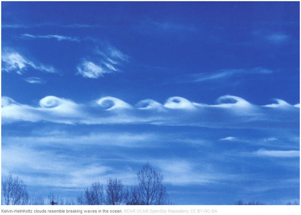
The Kelvin-Helmholtz cloud resembles a breaking ocean wave.
開爾文-亥姆霍茲浪狀云就像被打碎的海浪。
When air masses at different heights move horizontally with different speeds, the situation becomes unstable. The boundary between the air masses begins to ripple, eventually forming larger waves.
當不同高度的空氣團以不同速度橫向移動時,情況就會變得不穩定起來。空氣團的邊界開始起波紋,最后形成更大波浪。
Kelvin-Helmholtz clouds are rare, because we can only see this process taking place in the atmosphere if the lower air mass contains a cloud.
開爾文-亥姆霍茲浪狀云很罕見,因為這一過程只有在低處空氣團中有云時才會發生。
The cloud can then trace out the breaking waves, revealing the intricacy of the otherwise invisible motions above our heads.
從這種云展現的碎浪形狀可以窺見我們頭頂上原本看不見的微妙變化。
英文來源:The Conversation
翻譯&編輯:丹妮


 英語點津微信
 雙語小程序
雙語小程序